Collins children's picture atlas by Collins Maps
Illus. by Steve Evans. Collins/Times, 2019. 3rd ed. ISBN:
9780008320324. 48pp., hbk.
In all my years of teaching (nearly half a century!) either as a
classroom-based teacher or a teacher librarian, it has never ceased
to amaze me how little ones are fascinated by maps and atlases and
they pore over them for hours, dreaming dreams and making plans for
the future. I remember as a youngster spending endless hours with an
atlas mapping out a route around the world that would take me to
every capital city, and surprisingly (not) that atlas is now among
my treasured possessions inherited from my wanderlust mum, along
with an amazing dictionary that got just as much attention!
So there is no doubt that this new atlas for young children will
have the same sort of fascination for your young readers.
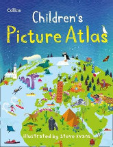
Designed to take children on a journey of discovery around the
countries of the world, it begins with intriguing endpapers of the
world's wildlife and then plots a contents journey around the
continents that is perfect for its target audience. Funky, colourful
illustrations depict a range of themes of the iconic features of
countries, building up a hankering to see these in real life when
they are older. Minimal text provides basic information and there
are the usual non fiction features like an index to help them
navigate their way through the book as well as around the world.
Guaranteed to provide hours of engagement and entertainment!
Barbara Braxton